From the National Weather Service
Birmingham, AL.
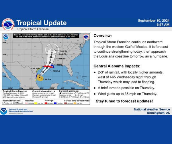
TROPICAL: There is a lot, so please look at everything! Tropical Storm Francine will continue to move to the north today and tomorrow. There will be a lot of rain, energy, and wind.
Tornado: There is enough energy and wind shear (turning of the winds) late morning through the evening, for any areas to produce a tornado. Though tropical tornadoes are typically weaker and short lived, A TORNADO IS STILL A TORNADO. Take any warnings seriously. Also, Friday afternoon, there could be another band that moves through in the afternoon. There will still be plenty of energy and wind for tornadoes to develop, so there is a threat Friday afternoon as well as today.
Wind: Gusts today could be as high as 45 mph in many areas. This is the GUST, a brief increase in speed. The sustained wind (the 2 minute, all-the-time wind) will be 25 to 30 mph today. The strongest wind gusts should decrease around midnight tonight, with gusting winds of 30-35 mph possible through Friday morning.
Rain: Because of Francine’s slow movement, there will a prolonged period of rain. A few bands could set up north to south and move consistently over the same areas. This will add to the rain totals already forecasted on the rainfall map, with a few areas possibly receiving over 6 inches today through tomorrow. Though central Alabama has been in a drought, these north to south bands could produce high enough rain totals to cause flooding.
Stay aware of the weather throughout the day.
-If you travel, check the weather BEFORE setting out. Allow for plenty of time, and plan alternate routes in case of flooding.
-Know where you would go to take shelter if a tornado warning is issued.
-Double check your ways to receive warnings and make sure you have multiple methods.
-Look up where you are in your city and county so you can have an idea of where you are on any radar/warning map information we might post.
We’ll post updates through the day, so please check back frequently!