From the National Weather Service
Birmingham, AL
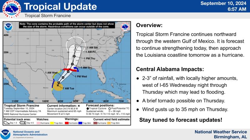
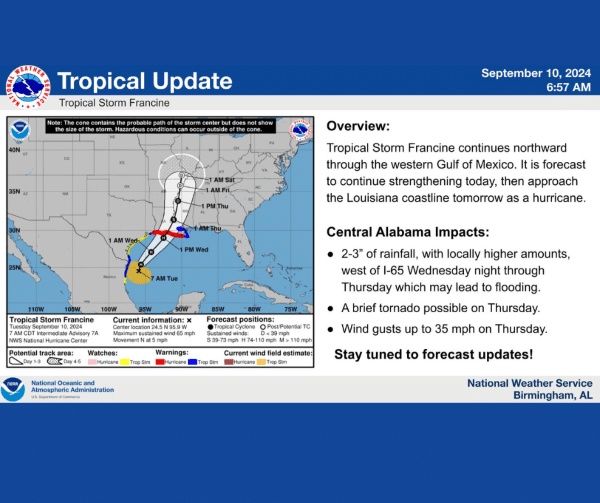
Tropical Update 7 AM, 9/10: Tropical Storm Francine continues to move north through the Gulf. Central Alabama could start to see an increase in rain and wind beginning Wednesday, with the greatest coverage/intensity Thursday. Let’s break it down….
RAIN: Showers will begin early Wednesday morning, increasing in coverage through the afternoon and early night. By early Thursday morning, coverage and intensity should increase, with a few storms capable of training through the day Thursday. (Training means storms could move over the same area consistently.) The higher amounts will be in the western half of the state (in areas closer to Francine), with 2-3″ on average and locally higher amounts possible. There could be localized/isolated flooding issues with any training storms. Right now, not expecting a widespread flooding threat, partially because of the amounts, but also because we were mentioning the word “drought” recently.
Wind: Winds will begin to increase Wednesday, with winds through the day around 20 mph across all of central AL. Winds will increase overnight, especially in the western half of the state, and by early morning, gusts up to 30 mph are possible. Thursday morning through the afternoon will see the highest gusts, with areas in the west seeing 35 mph or slightly above. Areas in the east could see 20-25 mph gusts through the day Thursday. Note: This is the GUST, not the sustained (the 2 minute, all-the-time) winds.
Tornado: Because of the way Tropical Cyclones move, the right side of the system is usually the best place for tornadic development. The way the winds turn, spin ups are possible. There is just enough ingredients Thursday for this to occur, so we needed to included a tornado threat.
Uncertainties: The track of Francine has been slowly drifting eastward. If this continues, the impacts listed above could be greater (higher wind gusts, higher rainfall totals). If the track moves on land and slows down a lot, impacts could be lower. We’ll keep an eye on the track and update as necessary. ALSO, the timing of impacts could change depending on how quickly/slowly Francine wants to visit.
What you can do: While it might not seem like we’re forecasting really big impacts, wind and rain is a scary combination, and if a tree falls on a house or car, that can quickly become life threatening. Conditions could change with each update, so please check back with us, the National Hurricane Center, and your local media! Also, make sure you are aware of every update Wednesday afternoon through Thursday afternoon. Double check how you get warnings and plan a way to take shelter if a warning is issued.