From US National Weather Service
Birmingham Alabama
Round 1: Thursday (1AM – 7PM)
A frontal boundary will slowly sag southward into the area after Midnight tonight bringing our first round of storms. As the storms initially move into the area (Marion/Winston Counties), they will carry a threat for all modes of severe weather (wind/hail/tornado). A weakening trend is currently expected as the storms approach the I20/59 corridor later in the morning. As we move into the afternoon hours, there could be an uptick in intensity as additional thunderstorm clusters develop east of I-65. The primary threats with this activity will be damaging winds and large hail.
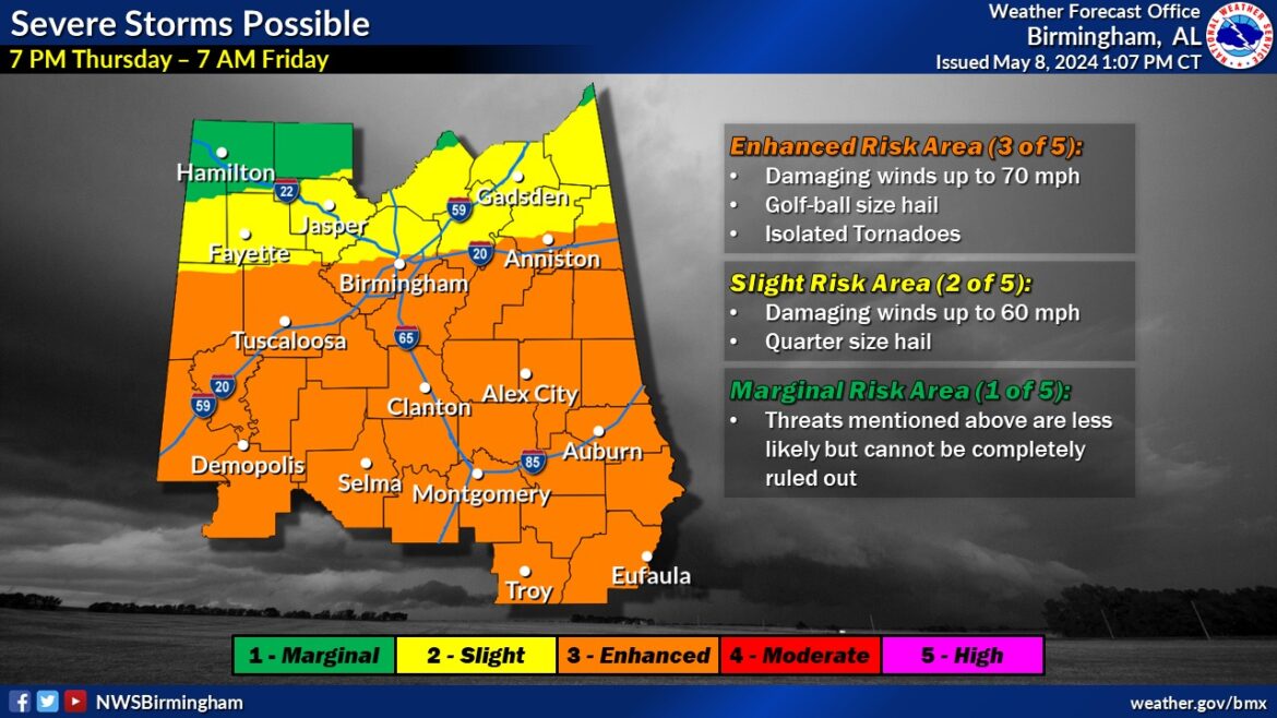
Round 2: 7PM Thursday – 7AM Friday
As we move into Thursday evening, we could begin to see more cellular activity develop anywhere across the area, which makes timing difficult to pin down. The main threats with these storms will be damaging winds and large hail. While these storms are ongoing, our attention will also turn to the west where a large thunderstorm complex is expected to develop and move eastward toward the area. This feature is currently expected to move from west to east across Central Alabama…beginning after Midnight in the west and ending by 7AM in the east. THE GREATEST SEVERE THREAT WILL ACCOMPANY THIS FEATURE! Prepare for widespread damaging winds, hail and the potential for a couple tornadoes.
If you haven’t already, please prepare BEFORE the threat begins!
– Have those safety plans and emergency kits ready to go.
– Have multiple ways to receive weather alerts.
– Know where your safe shelter is and how long it will take you to get there.
– Be able to find your location on a map (very important).
– Seek shelter for ALL warnings! Damaging winds can cause more widespread damage than a tornado.
Quick RECAP: Two rounds of severe weather possible: Round 1 – Overnight tonight into Thursday, Round 2 – Thursday evening into Friday morning. Overall, the greatest severe threat will be for widespread damaging winds early Friday morning associated with a large thunderstorm complex that is expected to move from west to east across the area.